Written by Bob Mecham.
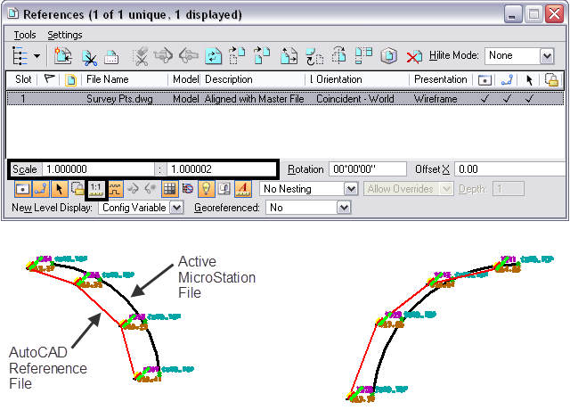
We have taken this support call twice in the last month so I thought I would share a solution with everyone in case you have the same problem. The problem is the user is attaching an AutoCAD DWG file to a MicroStation DGN design file. The coordinates in each of the files are correct but when the file is attached the coordinates do not match.
When referencing an AutoCAD file to MicroStation by default the Setting for True Scale is turned ON. True Scale if on, will take the units in the active design file and those in the referenced model are used to calculate an appropriate scaling factor so that the reference scale reflects a true real-world scale. This will cause a problem because AutoCAD is deemed unitless by MicroStation it assumes Intl Feet even if you set it to Survey Feet in AutoCAD.
Solution:
1. Reference the AutoCAD file as you usually do.
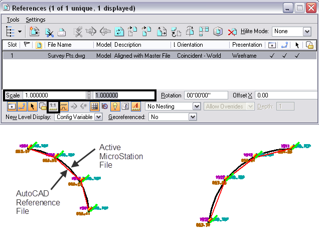
2. Turn OFF True Scale in the Reference dialog box.

3. Set the Scale Factor/Ratio back to 1:1

4. The AutoCAD file will automatically synch to the correct coordinates.
Every dataset is different so pay attention to your coordinates when working with files that are using Feet, or Survey Feet. Another solution that would work would be to use the transeed file and DWS options to help configure the attachment prior to attaching the file.

In the options area of the select reference file dialog box, when you have highlighted a dwg file, is a location where you can tell MicroStation that your AutoCAD file is in US Survey feet. when you do this, they attach correctly.
Also a similar problem can occur if you use a DGN file as an underlay in AutoCAD, or import it into a dwg.
This may have been true in 2012, but in 2019, I do not see any options that implies you can tell Microstation your dwg file is in any measurement format. Any new clues on this one? This answer is not working for me.
Thank you for your help.
Hi Mary Beth,
I can recreate what you are seeing.
My guess is you are trying to open an AutoCAD file release 2018/2020 in an older version of MicroStation that can not read the options. I tried OpenRoads Designer CONNECT Edition on a Civil 3D 2020 file and I could use the Options button.
If you have any other questions or assistance please contact us.
Thanks,
Bob Mecham
Sir
I need help i wanna convert autoCAD file to KMZ but when i convert i goes to sea with both Projection(UTM zone 43 and WGS84) can you plz help
Thank you so much for this, it really helped!
I am having a new problem related to this using SS10 ms converting dgns to dwg’s when i save as i get prompted what units i want,, i pick SURVEY feet
when i open the file in Civil 3d 2018 the units are in int feet, when i try to attached working files from the project all set to survey feet
of course there is that shift,, should I alter “seed.dwg” to be in survey feet?? ,I got a new workspace from NYSDOT not sure if the transeed is set right
i dont recall this problem in micostation ss2
Hi Karl,
I have SS10 and C3D 2020 and tried that workflow and got the same results. I would have to do more testing to figure out what and where to change to keep that from happening. I would start with the seed.dwg as well. I also got an error when I was opening the file about the version is only 2017 and it stores the coordinates differently. I wonder what ORD would do just for testing purposes and versioning. Sorry I can not be much help on this one without getting your files and workspace etc.
If I’m understanding this correctly, you’re saying a drawing in us-feet and a drawing in survey-feet should read the same coordinate for the same point? OR are you saying you need to turn off the true and set to 1:1 to get it to scale around 0,0,0 correctly?